Dating to 1865, this historic silver camp in the geographic center of the Silver State has an interesting history and continued interest in today’s silver mining legacy. Within the context of current electrification efforts, it is important to secure domestic silver production for the transition of the energy and transportation sectors. Silver’s single largest industrial consumer is photo-voltaic solar panels, raking in a total of 11% of annual silver supply. The Silver Institute estimates this figure could rise to 50% in the coming years.
Nevada will have a big role to play in mining domestic sources of critical minerals, and among those minerals critical to the transition is silver. Nevada has numerous historic and producing silver districts. Many of these precious metals systems can become metal-dominant to either gold or silver. Historically, the silver-dominant systems have been overlooked by the gold explorationist. So in a counter-intuitive way there is more silver to be exploited within the Silver State than ever before.
Belmont is located 45 miles Northeast of Tonopah, NV in northern Nye County. It is located on the Southeastern flank of the Toquima Range of central Nevada; located 20 miles Southeast of Round Mountain gold mine. The historic mining district is centered within some Private Patented mining claims from the original mining in the late 1800’s.
There are 10 precious metal deposits across complex geology along the Northumberland – Tonopah Silver-Gold Belt. This Belt runs Northeast from Tonopah in the south to Manhattan, Round Mountain, and Northumberland mines in the North. Within this trend there are both gold and Silver-dominant systems that are hosted within both Tertiary volcanics and Paleozoic sediments.

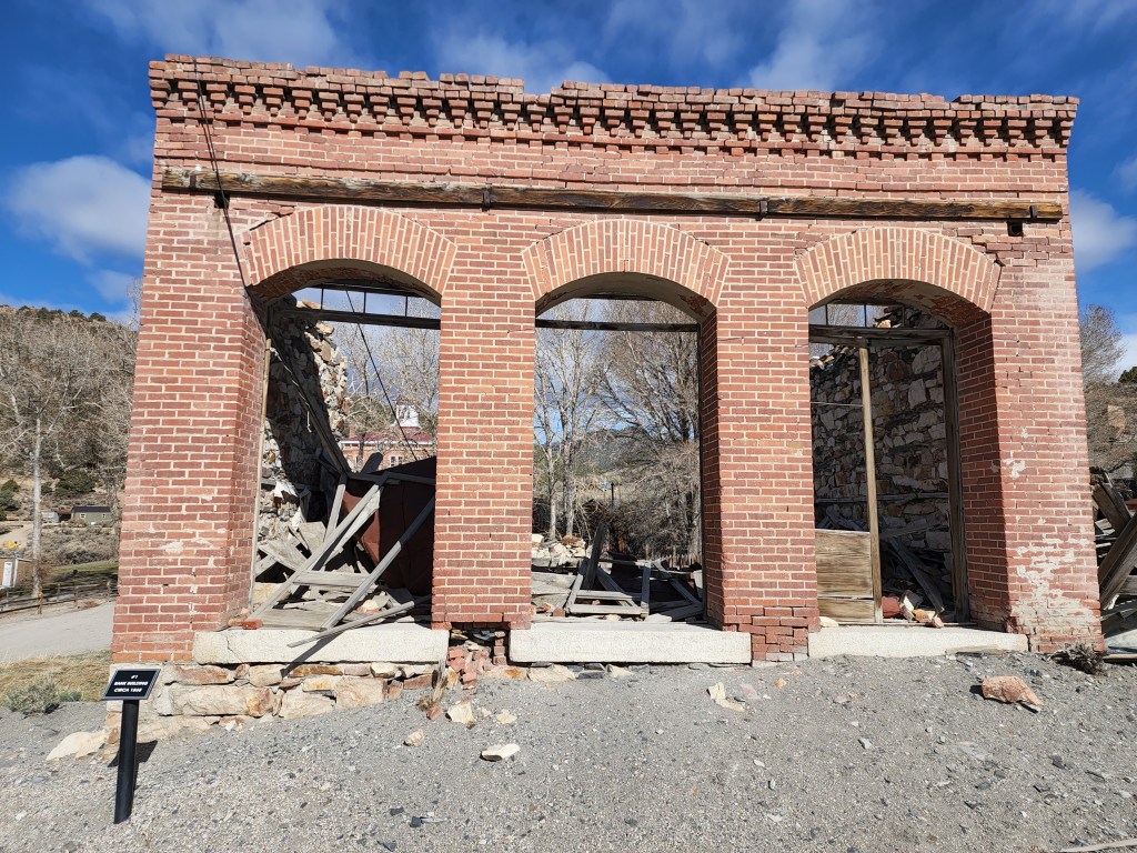
There still stands today, the original Nye County seat courthouse in the middle of town at Belmont, NV. Established as the county seat in 1867, Belmont served that role for the county until 1905 when Tonopah was gathering more than a little attention. There are still several surviving store fronts and original buildings within Belmont town site today, such as the archways of an old bank building that you pass on your traverse thru town on NV State Route 82.
The Belmont silver mining district is attributed with 20 years of original production from 1865 thru 1885. This was during the height of the Nevada Silver Rush within such famed districts as the Comstock in Virginina City, NV. Other names for the Belmont district were: Philadelphia, Silver Bend, Barcelona, & Spanish Belt. It is commonly confused with the Belmont mine and mine-fire in Tonopah, NV. As is common in mining culture, successful names get re-used in other districts, such as the well-known name of ‘Belmont’ by the time Tonopah was coming on line after the turn of the century.

There are various reports that publish estimated silver production numbers anywhere from $4 million to $15 million (citing Kral, 1951 & Lincoln, 1923, respectively). Ore was reportedly produced at $80 per ton and grades of 25 ounces per ton. With these numbers we can calculate the estimated amount of mined silver ounces between 1.5 and 4.7 million ounces. Considering that these numbers come from primitive underground drift and stope mining methods it is impressive nonetheless as this represents at least 50 tons of mine muck per day stretched over 20 years.
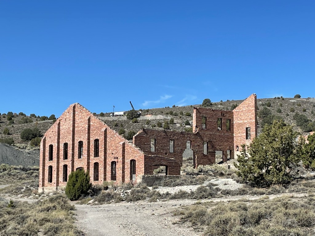
Continued interest over time saw revitalization of the Belmont district since first mining. The Monitor-Belmont Mining Co. built a 20 stamp flotation mill on the site of the old Highbridge Mill. Purportedly, these same bricks were used in the original mill or stolen from surrounding mill ruins such as the Combination Mill located closer to Belmont town site. Again in the 1960’s, Summa Corp., a subsidiary of Howard Hughes, backed exploration and sampling efforts at Belmont. Followed up by with a heap leach facility ran in the 1980’s to treat old mine dumps.
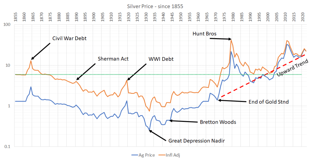
Until the 1860’s, silver was at a set price of $1.29 per ounce due to the Mint Act of 1792. At this time, the US was on a bimetallic monetary system that backed the dollar against both gold and silver. Civil War debt was the orginal stressor that saw silver price nearly triple within a short period of time. Even before this price spike there was a fair amount of gold and silver interest and mining within Nevada such as the Comstock. Several governmental policies successively undermined and drove down the price of silver such as the Coinage Act of 1873 that effectively demonetized silver. Followed up by the Sherman Act of 1890, that saw buying and minting of silver to the Federal government resulting in the Panic of 1893. And then the final nail in the coffin, the Gold Standard Act of 1900 where gold became the sole monetary precious metal.
There was a brief-lived rebound in silver price during war-time again with war debt from World War I. At Belmont, this saw the building of the new Highbridge mill and brought electicity in from Manhattan, NV to help dewater the old underground workings. Even still, the renewed effort was short-lived as silver price continued its slump until its nadir during the Great Depression. The first US-led effort that helped silver price was the Bretton Woods agreement of 1944, where President Franklin Roosevelt signed with other european nations to set the dollar as the world’s reserve currency, backed by gold. Gold price was set at $35 per ounce for this agreement, which was a devaluation of the metal by 70% at the time.
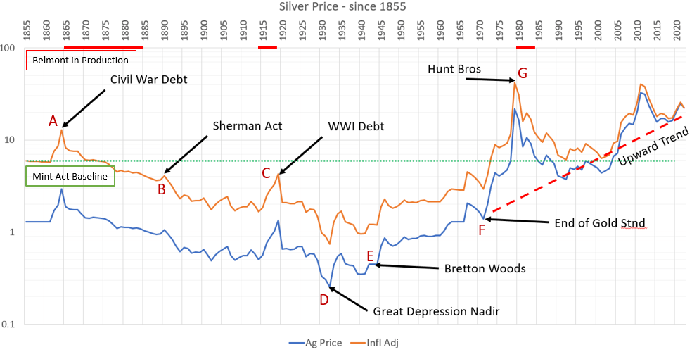
Several Nixon Era policies completely dissolved the Gold Standard and decoupled gold from backing the dollar. So by the time the Hunt Bros. caused a run on physical silver bullion in 1979, silver was long overdue a significant price increase and re-valuation. If you adjust for inflation, the silver price set during the Hunt Bros time is nearly $45 per ounce. This throughline of history for silver price can be seen through the lens of the Belmont silver district with it’s own ups and downs.
In the context of Belmont history some key take-aways can be summarized thus; producing years coincide with the Nevada Silver Rush, it was the Nye County seat from 1867 until 1905, the district mined in decline, constantly chasing down a declining silver price, the district was forced to mine more narrow & high-grade each subsequent year, all while using primitive mining methods with simple tools and manual labor.
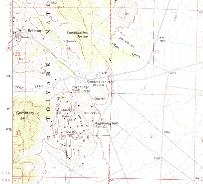
The physical town site of Belmont is located Northwest of the mining district by about a mile or more. Some mill sites were located in Belmont itself, but most of the larger scale mills and all underground workings and mining occured in the main part of the district Southeast of the town. Geographically, the Belmont mining district runs along a North-South set of hills that defines the line between Ralston and Monitor Valleys. There are numerous adits, shafts, declines, and associated dumps and tails thru out the district. Additionally, there are several old stone-built cabins that presumably prospectors lived out of during mining or perhaps before the town of Belmont got fully established.
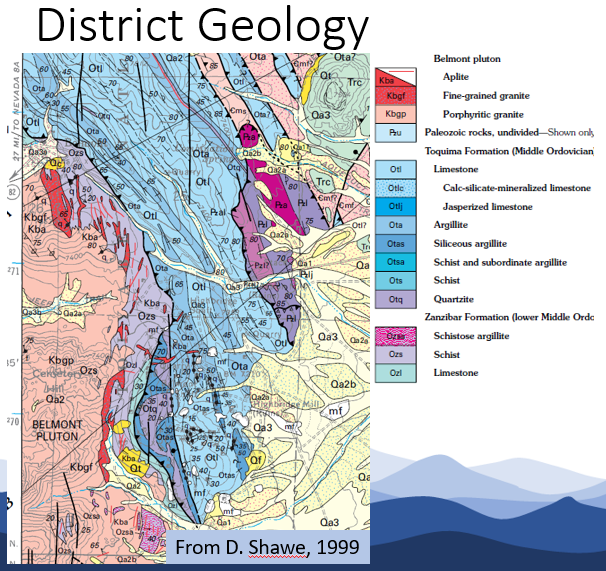
District geology consists of Cretaceous Granite and Paleozoic strata along a structurally complex axis bewteen two larger mountain ranges. The Belmont Pluton is the name of the Cretaceous Granite that lies in the Southwest of the Belmont District. This pluton underlies the Paleozoic carbonates, argillites, and quartzite of Ordovician age. These sedimentary rocks dip East to Northeast into Monitor Valley on the Southeast flank of the Toquima Range. In addition to complex structure, involving both thrust faults and basin & range normal faulting, the Belmont Pluton has associated contact metamorphism with the Paleozoic strata. Throughout the district can be found aplitic dikes and sills as well as base-metal porphyritic alteration in the southern end of the district.
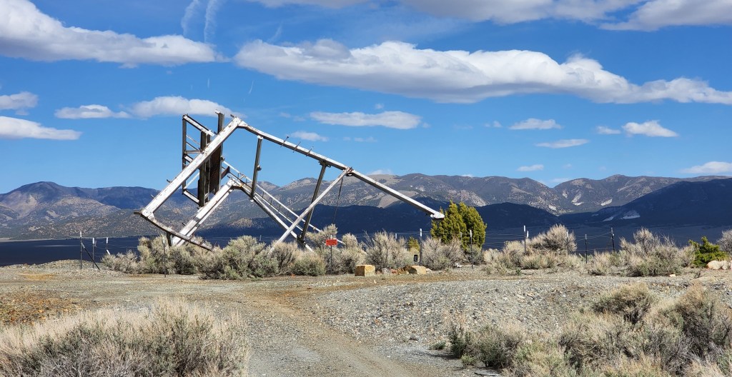
The vein mineralization style at Belmont is a silver, lead, zinc quartz vein system. Other metals associated with the system is copper, antimony, and bismuth. Two historic vein trends extend North-South thru-out the district separated by about 1,000′ (1 kilometer). The Highbridge/Transylvania vein system is on the East side of the district, whereas the Arizona/Eldorado vein system sits on the West side of the district. Historic workings have relatively shallow workings in the North with progressively deeper workings going South. Presumably this progression correlates relative to time, with the earliest diggings in the North and the youngest shaft and headframe in the South (still “standing” today) that reaches 1,000′ (1 kilometer) deep into the earth. Initial mining focused on the supergene enriched silver ores found near surface. Vein width within the quartz vein system varied from 2 feet up to 30 feet wide.
Many of the quartz veins and “pay zones” were found in fault gouge parallel with the vein system. The syn-bedding structures and veining dip shallow to steep across the district from West to East. There is right-lateral vein offset along East-West striking faults, presumably youngest. This youngest set of faulting would most likely be associated with regional Walker Lane tectonic motion. Recent mapping in the district suggests that there could be isoclinal folding of the Paleozoic strata, especially on the Eastern side along the Highbridge/Transylvania vein system. The recent mapping also confirmed base-metal porphyry alteration in the south end. However, copper mineralization can be found along with quartz veins throughout the district.

The silver-bearing quartz veining carries silver chlorides such as cerargyrite. Sulfide, pyrite, and arsenopyrite along with other lead or zinc minerals are found throughout the system. One refractory copper mineral, Covelllite, was found in recent core drilling.
Nevada Silver Corp. conducted exploration work at the Belmont project area including: IP/Res geophysical survey, geologic & structural mapping, initial exploratory core drilling, and surface sampling. The IP survey identified twenty-four discreet targets across the project area. Mapping identified the vein system footprint and favorable geology. The first-pass drilling completed six core holes with an average depth of 550′ (180 meters). And the surface sampling collected 40 plus samples from old workings, dumps, vein outcrops, and open cuts.

The IP/Res survey was collected on seven lines spaced 200 meters apart. The survey identified a potential zonation of altertion or differing host rocks. The twenty-four targets were chosen from the interplaying anomalies across the survey. The survey helped to highlight the vein systems at depth and the breadth of the mineralizing system.
The surface geologic & structural mapping included lithologic units such as: limestone, siltstone, sandstone, shale/schist, quartzite, as well as aplitic dikes and granite. The mapping includes detailed structural data for use to unravel the complex structural story. All of this information was brought into 3D modeling software to digitize the mapping, highlight the fault and vein trends, integrate with IP survey data, and visualize the system in 3D and at depth.
The recent exploration drilling is unwittingly the first exploratory core drilling completed on the property. All previous exploration was during original prospecting and mining efforts in the 1860’s, prior to any modern-style drilling or exploration. This was the first half dozen core holes to test ground that has seen an estimated 5 million ounces of silver produced within a precious metals belt (Northumberland – Tonopah Ag-Au Belt) that has nearby silver deposits of 50 million ounces or more.
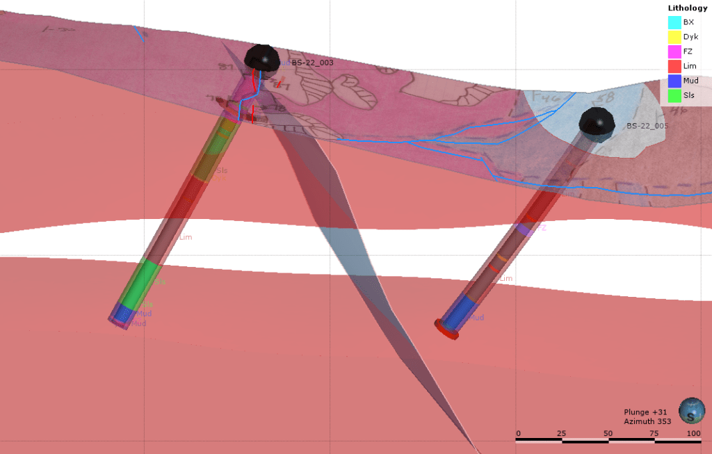
All drilling utilized private patented ground wherever possible and each hole was designed to intercept the vein system or IP survey target across a two square-kilometer area. The average dept of each hole was 550′ (180 meters), generally drilling West with a moderately steep dip to cross-cut the lithologic units. The entire hole, after logging, was sent to an assay lab for analysis. Each hole came back with silver mineralization. Two holes encountered bonanza grades at shallow depths (holes BS-22_002 & 003). Hole BS-22_003, located along the Highbridge vein system encountered silver mineralization from 0′ to 150′ deep at 28 grams per ton silver with 25′ of 90 grams per ton therein. Hole BS-22_002, located along the Transylvania vein system, encountered 20′ of 107 grams per ton silver with a high-grade core of 440 grams per ton silver at only 90′ deep.
In addition to the geophysics, detailed mapping, and core drilling program, there was also some surface sampling completed as well. The surface sampling effort makes up 40+ samples from vein outcrop, old mine dumps & tails, plus open cuts. About 25% of the samples came back with bonanza style silver mineralization. One sample in particular assayed to 1,061 ppm Ag (or nearly 35 ounces per ton silver). These results confirms the silver-dominant system with a base-metal signature. The bonanza grades also confirm the historic production reports that cited a grade of 25 ounce per ton.
In all, the recent exploration results at Belmont have been positive. Initial drilling has yielded positive results. The IP survey and mapping have illustrated a complex but favorable mineralizing system. Interpretation of drill results in 3D have put things in context such that follow-up targets can be developed going forward. In the coming years this old district could see a revitalization and reevaluation of the true size and scale of the silver-dominant metal system in place.